 |
All dressed up and a long way to go. Click on photograph to enlarge |
 |
Approaching Ennerdale Water overshadowed by the heights of Grag Fell which is enjoying the caress of low soft cloud. |
 |
Early morning trampers enjoying a stroll besides the lake of Ennerdale Water, beneath the towering heights of Angler's Crag. |
 |
The path follows the water's edge to the point which is Robin Hood's Chair. |
 |
The northern boundary of the lake touches the sky. |
 |
The long view of Ennerdale Water and a 'typical' Lake District sky. |
 |
The morning remained overcast and dark. Fortunately there was little wind to enliven the occasional showers. |
 |
From the 'lookout' of Robin Hood's Chair towards the head of the lake which is our objective. |
 |
The uninviting thrust of Angler's Crag from where even the most ambitious fisherman would be unlikely to catch anything other than a cold. |
 |
The misty valley down which flows the River Liza to lift the level of Ennerdale Water. Our path is the cart track on the right. |
 |
A stream running down from the high peaks of Red Pike, High Stile, High Crag or the Hay Stack, a route denied to us by the thick mountain mist. |
 |
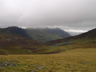
Several peaks off to the south. |
 |
Our first sighting of Black Sail YHA hostel glimmering in the near distance. Here we feasted on hot tea and cake amongst a steaming mod of red faced fellow trampers. |
 |
The path leading towards the near vertical climb known as Seavy Knott which follows the tumbling waters of Loft Beck. |
 |
Looking back westwards towards Ennerdale Water to where the cascading flow of Loft Beck is heading. The path may be seen on the left running around the flank of the hill. |
 |
From the tops, beneath Brandreth and Grey Kotts, looking north to Fleetwith Pike where the land falls away to Buttermere, the lake in the distance. |
 |
Beyond Fleetwith Pike the hillside is scarred by a hard rock quarry. |
 |
The mist lifted exposing the high route across Red Pike, High Stile, Comb Crags, High Grag, Scarth Gap and High Stacks. We'd save that walk for another day. |


No comments:
Post a Comment